Hawaii, as seen or recommended through Our eyes.
We have visited four of the eight Hawaiian Islands: Kauai, Maui, The Big Island, and Oahu. Each has much to offer, so it is difficult to choose a favorite. I will share my thoughts on each, with a few places I recommend you visit. At the end of this guide I have included several of my journal entries, along with a few bits of information that will allow the traveler to learn more about his magical place. The current issues with COVID-19 (2021), along with challenges of every day travel, along with history and cultural information have also been added.
Kauai was our first exposure to Hawaii.
When planning our first trip I wanted to find a place with least amount of crowds. After much research Kauai was at the top for my requirement, especially in September, the month we usually travel to celebrate our anniversary. Kauai has much to offer from the simplicity of relaxing with cool tropical breezes in your face, to fantastic hikes.
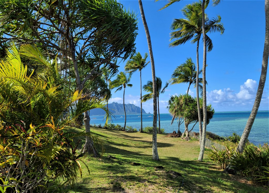
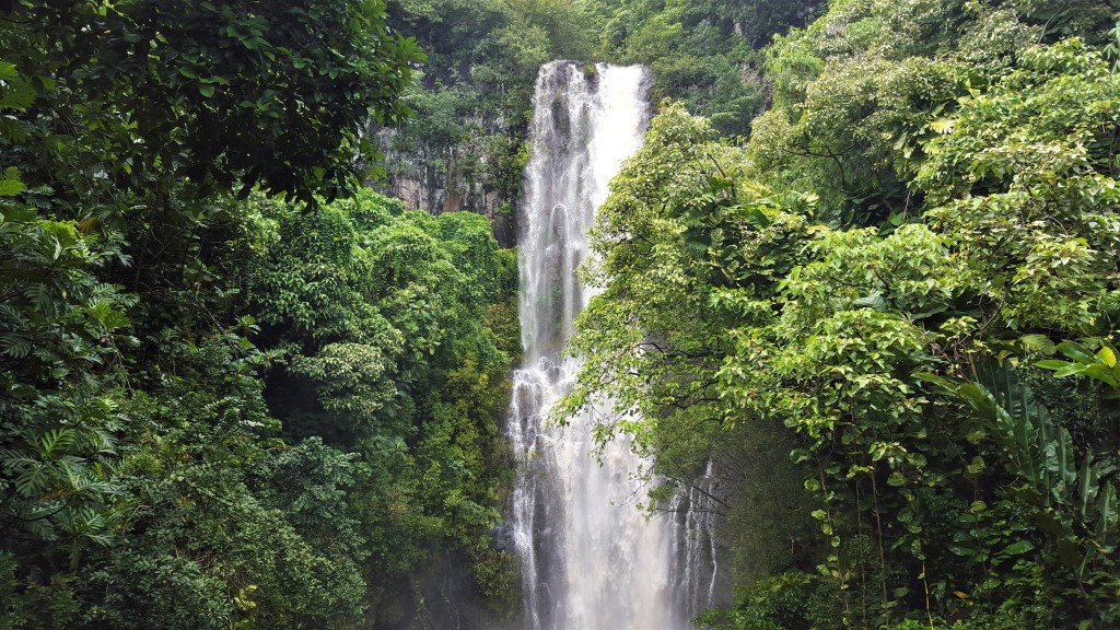
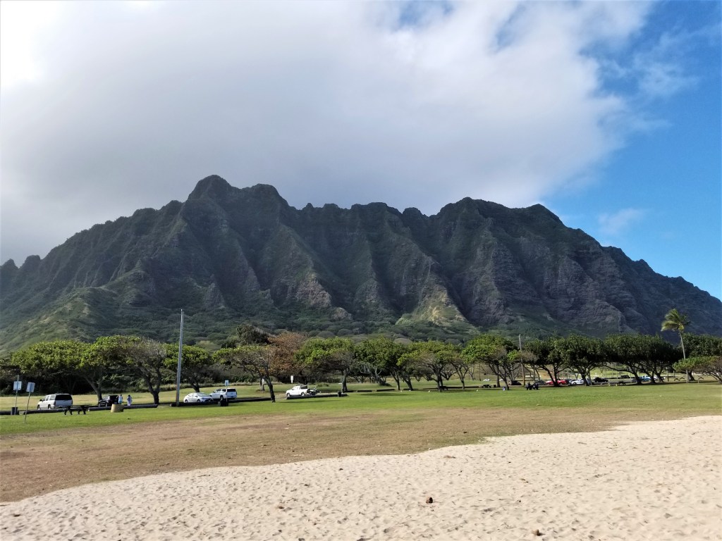
- Beauty of the land: Like most Hawaiian islands the steep tall mountains divide the island between lush rain forest and very dry arid areas. This is of course known as the windward/leeward effect of the mountains stopping prevailing sea-winds, thus moisture, in the form of rain falls on the windward (Usually east and north east side) of the island. This is quite pronounced in Kauai. As I recall, there is a small area of the island that receives more rain than any other point in the United States. There are many waterfalls, some quite high and long as a result of the rain. As you travel around the island look at the mountains, and you will likely see water falls in various places.
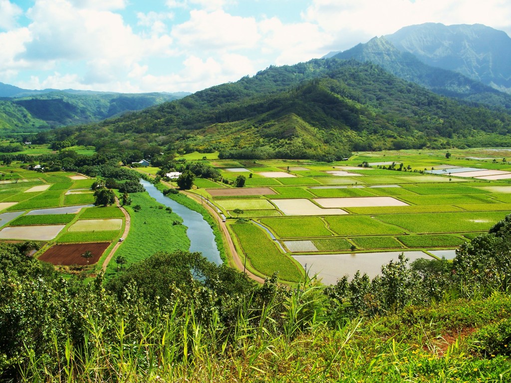
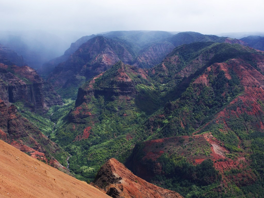
- The ‘Grand Canyon’: On the southwest side of Kauai there is a very large canyon. It does appear like the Grand Canyon in Arizona, to a large extent. Wear comfortable hiking shoes, a small backpack, and a few bottles of water, and do a short (or long) hike. If not, just the view is worth the short ride.
- ‘Last Beer Before Tomorrow’: There is a little brew-pub about five miles from the Grand Canyon. The pub claims it is the most western brewery on this side of the International Date Line, it is the last beer you can have before tomorrow. Nice brew, reasonable prices, and great views.
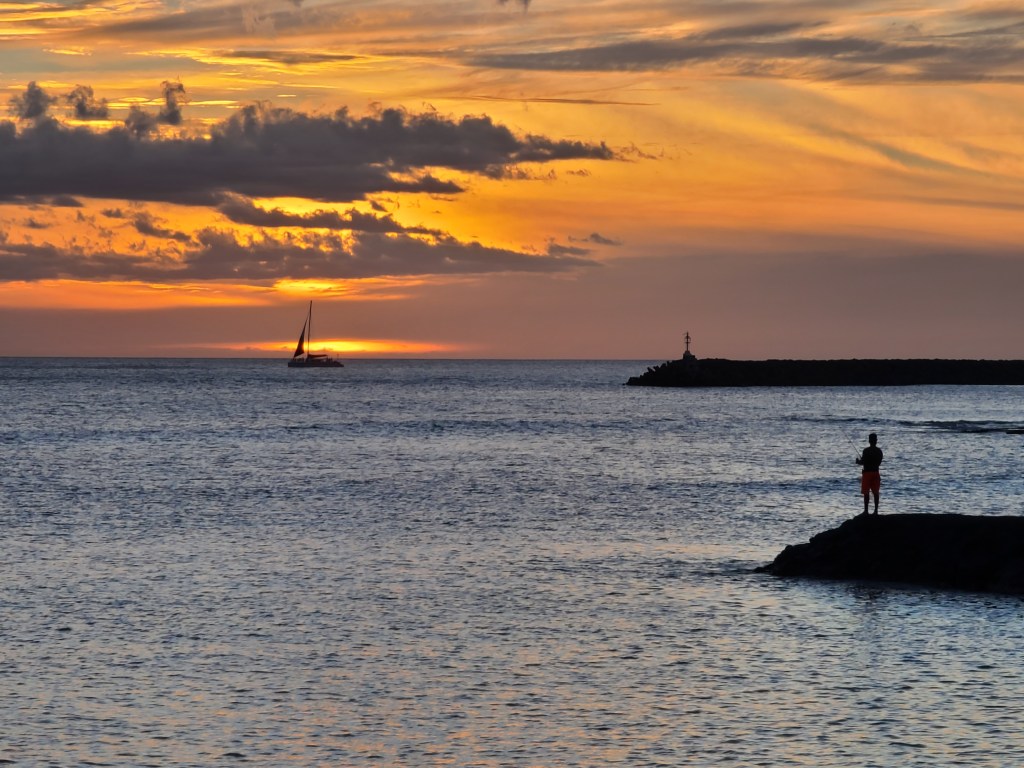
- Dinner cruise aboard a catamaran. We did this from the south shore of Kauai, and it was a blast! The service was great, the food good, and what a view. The cruise takes you up the west coast of Kauai, a place not reachable from land. The view of the mountains is breathtaking. About a third of the trip is under sail, so little noise other than the wind. The cat (boat) is quite comfortable. I suggest on the way back you sit up on the tarp, between the two pontoons. It gets quite bumpy, but wow is it fun. The only downside of this trip is that you must bring a designated driver, or plan to get a taxi. Included with dinner, and throughout the trip is ‘bottomless’ Mai-Tai glass. They are sooooooo good, and go down so easy…..beware!

- Northern Beaches – There are beaches on the north side that seem to go on forever under cliffs. Our last night on Kauai we drove our car right down on the beach, and enjoyed a jug of frozen margaritas we brought with us. Beware; like any fairly deserted beach in Hawaii, you might find the couple or two of the nudist persuasion. Certainly don’t knock it, but be aware.

- Tours and Luaus: There are some good tours of the island. Find one to take, as you will learn of the people of the island, and a bit of their history. Experience a luau, come hungry, but have fun. One is about the same as the next, so you probably will not want to do many of these.
- Explore!! If you have a car use it. There is only ONE major road, so difficult to get lost. Drive the entire length of it, about fifty miles. Top speed is about 45, but mostly less, and the local police love to give tickets. You will love he scenery.
If you only to Hawaii once in your life, and can only do one island……I recommend you visit Kauai!
Maui: A place to relax or Party
We spent a week with our dear friends in Maui. It was a lovely island with some wonderful beaches. The island is long, with the eastern half of the island a very large and very high dormant volcano. The western side of the island is half volcanic mountains, and ‘The Beach’. Most tourist hotels and facilities, along with the cruise ship port is in the southwest portion of the island. At the ‘waist-band’ of the island is the Kauai airport, which is very nice.
- ‘The Road to Hana’: You must do this trip, but take a tour bus….do NOT attempt to drive yourself. The road wraps around cliffs along the seaside of the volcano. The tour stops several places along the way, with a lunch stop in the small town of Hana on the far east of the island. You can drive, but it is extremely dangerous, and paying attention to the road (it is extremely curvy, narrow, and at times cliff-side), one cannot enjoy the beauty of the place. You will see glorious views of the sea, waterfalls, and dense tropical jungle. The tour takes up most of a day, but so well worth the time.
- Beaches: The beach on the southwest side of the island literally runs for about fifteen miles. There are many places one can pull off the main road to enjoy your own private beach. There is a park on the south central side of the island with a beautiful beach called ‘Little Beach’. I forget the name of the park, but there is generous car parking here. I have read, if one is inclined, there is a path to walk over a little hill at one end of Little Beach to another smaller beach named ‘Secret Beach’. Here one can enjoy clothing optional experience if wanted, and there apparently is a ‘drum circle’ often at sunset where many folks play drums, and the wafting smell of pot can be present. There are a few smaller beaches north of the island. The closest one is about three miles up the highway northeast of the airport. Be careful getting in the water on these beaches, as the undertow is pretty bad here. One of the beaches is a place where ‘kite-surfers’ often gather. It is a delight just to relax on the beach while watching dozens of these brave folks doing their thing with colorful kites propelling the surfboards across the waves. I highly recommend this little visit.
Oahu: An island of contrasts
I have spent a total of about six weeks on Oahu during my four trips to Hawaii. I know the island quite well by now. There are many positive things about Oahu, and some not so nice. I will divide the island in several large segments, as they each contain such contrasts, but each have such nice features. Of course there are some negative things also to discuss. I think for this writing I will get the negative things out of the way, so you the reader will have positive impressions when you finish this read.
Where to stay On Oahu: Oahu, like most of Hawaii is a very expensive place to stay. Choices of places to stay vary between homes/cottages to rent via websites such as VRBO.com, normal hotels and resort hotels. Most of the tourist beach resorts are in three areas of the island. The per night charge is from $180 to $800 per night. As you book a hotel, make sure you have the TOTAL cost, before providing your credit card number. It is not uncommon for a hotel to charge a ‘Resort Fee’ and ‘cleaning fee’ on top of the room charge. There are of course sales, and tourism taxes on top of this. At times the additional fees and taxes can add over $100 to your daily room rate.
Ko ‘Olina – This Disney designed resort is located about eight miles northwest of Pearl Harbor. The hotels are wonderful, the area is like a garden, and the man-made beach lagoons are post card beautiful. This resort area is pretty self-contained. This is one of the MOST expensive areas to stay.
Turtle Bay Resort – This resort is located on the far northeast side of Oahu. The resort and golf course is pretty isolated, but again beautiful. There are a few towns about six miles southeast of the resort, where the Polynesian Culture Center is located. Turtle Bay is located about one and half hours north of the airport. The fifteen miles west of Turtle bay is dotted by numerous perfect beaches, along with the small town of Haleiwa (A village you must visit while on Oahu.
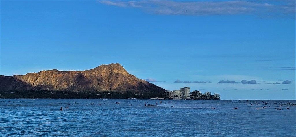
Wakiki- This district located on the southeast edge of downtown Honolulu, is the best known beach areas. We have long seen this area in movies and TV shows. This area is EXTREMELY dense. Giant hotels, upscale shops and restaurants, and large crowds. There are smaller hotels a block or three from the beach. In almost all cases the walk to the beach can be a few blocks. The beach however is beautiful, if not crowded. Room prices can vary depending on how close to the beach sand.
Sadly, there are few if any, hotels on the most beautiful side of the island. The east (windward shore) is a miles long lush forest/jungle along the base of the mountains. There are a number of private cottage rentals on this side of the island however, but one must search the net for them. For the nightly cost of a simple hotel room in one of the above resort areas, one might be able to find a private cottage/home here. This would be ideal for two couples or a family traveling together.
Other Hotels:
Like many American cities, the normal hotel chains have many hotels along freeways in the Honolulu area. The ocean facing areas of downtown Honolulu have many hotels, some quite nice. Downtown Honolulu is quite nice, but as in any large city, just beware of things around you.
World War II Sites: We all know WW II started for the US here at Pearl Harbor. It is amazing however how little WW II history has been preserved.
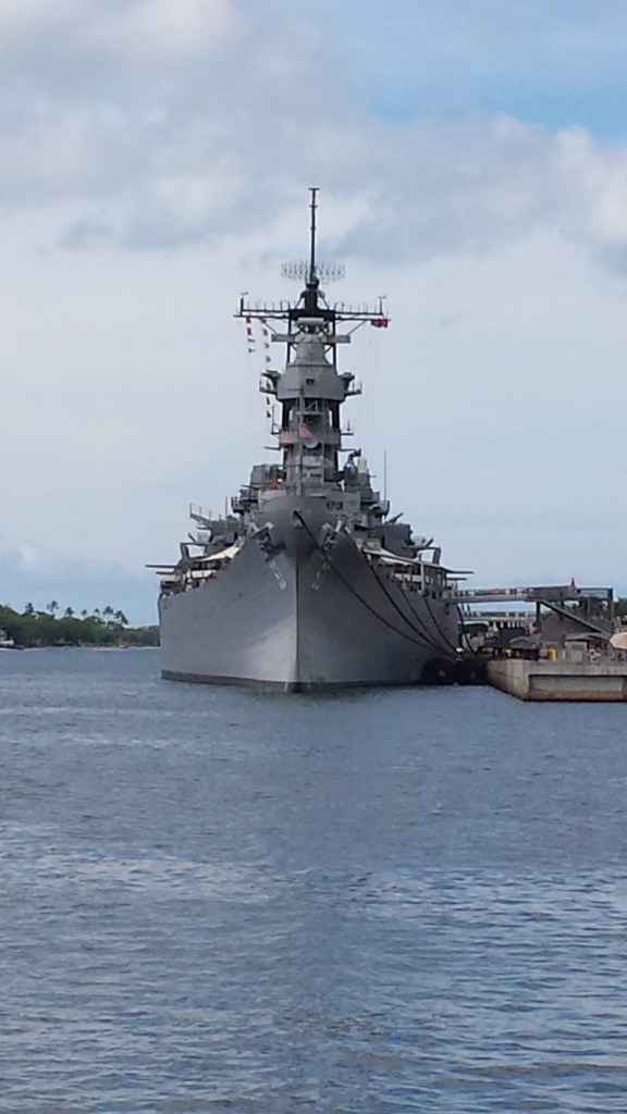
Pearl Harbor
This well preserved site is an absolute must see while in Hawaii. Plan to spend three or four, or more hours here. Take your time to browse the museums. You will learn more about the actual battle, but also the perspectives of local folks, and even the normal Japanese troops involved in the horrible day. Part of your tour will be a short visit over to the USS Arizona memorial. Expect to shed a tear or two here. Take the time to tour one of the surviving battleships, which is anchored on Ford Island, just down the shore from the Arizona.
Note: I am not sure of the impact of COVID, but know tickets to Pearl Harbor go pretty quickly each day. I would advise you do what we did: Find a tour of Honolulu that includes Pearl Harbor. This way you get to enjoy different historical areas of the Honolulu area, but also they make sure you get a ticket to Pearl Harbor.
Hickam Field
If you, like most of us, have seen the Pearl Harbor movies, you will see some of the first scenes the large Army Air Base at Hickam was attacked first. Today, Hickam is still a very active US Air Force Base. If you fly into Honolulu Airport, you will be landing on some of the same runways bombed on that terrible day years ago. The airport is on one side of the runway, and the air base on the other side.
Dillingham Field
This WW II Army air filed on the extreme northeast shore of Oahu, is still quite active. Instead of protecting Oahu from the north as in WW II, it now serves as air tours, glider rides, and sky diving for tourist. The road to the area is a beautiful drive with about a dozen beaches along the way.
Other WW II sites
There are many tiny WW II sites. You can find these online, and on some online maps. Google Maps on most cell phones will point out some of these. Most of the sites are simply concrete pads when giant gun emplacements were located before and during the way. There are many ‘pill boxes’ located around the island located up on hill sides. Some of these are open to hikers, but beware of the effort it takes on a warm afternoon to visit these.
Sadly, with the insane property cost of land in Hawaii, many of the old WW II sites simply have been built over. All in all, with the exception of Pearl Harbor, there is not much WW II history one can see on Oahu.
_________________________________________________________________________________
Poverty: The native Hawaiians, and mixed Asian descendants have really been dealt a dark hand by white folks who started coming to Hawaii since British Captain Cook first touched the islands in 1778. Exploitation by folks from the mainland US and some from Europe resulted with many descendant families being trapped in terrible poverty in a place with extremely high cost of living. Many neighborhoods are little better than slums, with issues such as drugs, and now COVID. Homeless folks can be seen living on the beach or near the beach in many places. These folks are a combination of locals as well as mainland folks who have fallen on bad times. Just beware of things like valuables. At beaches or other scenic areas you will see signs not to leave valuables in your car, so just beware.
Travel by car is easy, but at times traffic can be interesting. There are three main roads (mostly Freeways) on the island. These are federal roads, exactly like the interstate system on the mainland, but since they are only on a single island, the designation are simple: H1, H2 and H3.
H1 starts on the far northwest and ends in the southcentral side of the island. The road actually starts at the far northwest tip of Oahu, known as the Farington Highway, which is a state highway. Farington runs south for about ten miles until it becomes H1, and becomes a freeway. The H1 runs a great deal along the coast at an elevated level on the side of hillsides. This provides wonderful views of the ocean, and distant views towards the mountains. H1 runs by the Honolulu Airport, then southeast through Waikiki, and finally ends as a state highway.
H2 is the route from the Honolulu area to Oahu’s ‘North Shore’. This easy drive runs over Oahu’s divide in the mountains. It is amazing that within a couple of miles the land transitions from arid land to lush forest and farms. The freeway ends and becomes a state road at the large Scofield Barracks Army base. From here you can take the state road to Haleiwa and the main part of the north shore, or west towards the old Dilingham Field Army air base, now used for glider rides and sky diving.
H3 is the one route you MUST take if you can only drive once on Oahu. H3 runs from just northwest of the Honolulu airport to the eastern side of the island. This route is winds along a river through the center of the island. You get the feel you are driving through a rain forest the entire journey. About ten miles from Honolulu you enter a tunnel: be prepared for one of the most beautiful scenes of your life as you exit the tunnel! You will be pretty high on the mountainside with miles of forest and ocean in front of you.
Now to the good stuff!!!
I will circle the island in the following information.
West Side:
For definition of this guide, I designate the west side starting from just north of Pearl Harbor to ‘the end of the road’. From the Pearl Harbor area the H1 freeway then the state highway it becomes, runs about twenty miles up the west side of Oahu to the dead end. The road hugs the seashore for the most part and offers great views. Many beaches provide access to enjoy the ocean. The road ends in a fairly remote but beautiful park. The route follows where a plantation baron built a railroad to provide access from Honolulu around the northwestern point of Oahu, over to the north shore. Many decades ago hurricanes wiped out the last ten miles or so of tracks around the tip of the island. There is now a nice, long, but arid hiking trail along the route from the end of the highway. The area along the route, especially the last five miles or so, provide beautiful views of mountains and sea. Sunsets from beaches along the way are breath taking. Note: You will find small areas of homeless folks here, be aware, but you are safe. Just remember don’t leave things of value in your car or visible in your car.
There are a number of snorkeling boats an scuba dive boats in the Wainae Boat Harbor. These boats put you up and close to large sea turtles and dolphins in safe trips.
Pearl Harbor
This is one of those things you MUST do if you are visiting Oahu. The story of the horror of the day that triggered the US entry into WWII is amazing. You will learn much and at times a tear or two may emerge from your eyes. Note: It is best to book long before you leave home, if possible, for the Pearl Harbor experience. Take advantage of the tour of the museums, the USS Arizona, and tour the large battleship.
Honolulu and Waikiki
Honolulu is a very large city like Houston or Dallas. It so happens the beautiful sea is on one side and lush green mountains are on the other side. There is a beautiful long beach park, I think with the name of Alia Morena, downtown in Honolulu. This is a great place to enjoy the beach, the boat harbor, or simply watch surfers with the city and Diamond Head in the background. Beware while in Honolulu of your surroundings. Even though much of the city’s economy is based on tourism, and is safe, it is still the typical large city. Just beware, but enjoy.
Waikiki is a disappointment to me. My original thought of this place was the beach scenes in old Elvis Presley movies from the 1960s. Yes the beach here is fantastic, no denying this. But the area reminds me of Las Vegas, just absent gambling. Giant hotels, upscale shops and restaurants, tons of people, gives me a feeling of claustrophobia. I highly recommend if you plan to visit Oahu you find a place to stay outside of Honolulu.

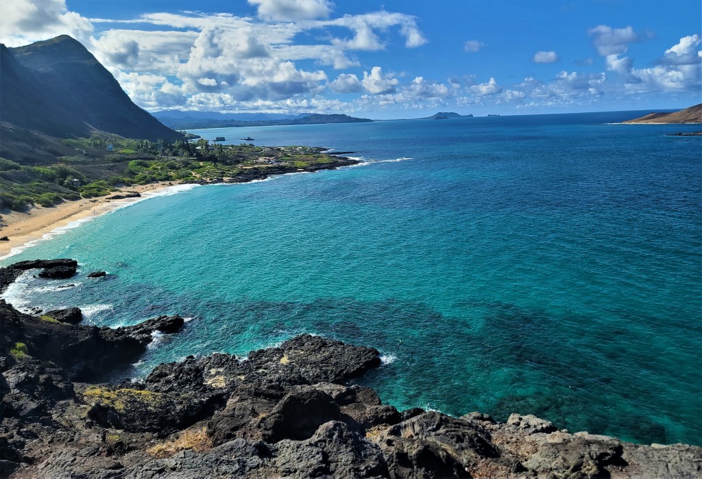
Southeast Oahu
If you have a car, you owe it to yourself to drive the H1 to the end of the freeway, then continue on the state highway as it runs around the far southeast of Oahu. You must pull over at each of the little scenic pullout places, get out of the car, and just feast your eyes on the scene in front of you. There are about a dozen of these along the way. Many of these are on sides of cliff, so the view is startling beautiful. Continue on the ride up the east side of the island until the road meets the H3E then if time is short or you are tired, head back to your hotel.
Eastern Shore Oahu
There are several options to see this side of Oahu. If you are rested and have an entire day when driving around the southeast ‘corner’ of Oahu, continue north along the shore past the H3. If you want to break things up, then drive out on the H3, turn left and drive up the east coast, around the ‘northeast corner’ and back down the H2 highway to your hotel.
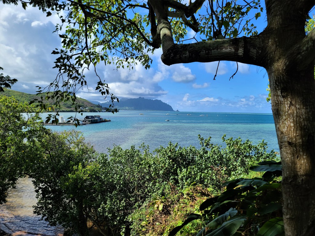
The drive itself is Wonderful! You will wind through rain forest and shoreline. You will NOT get in a hurry because of the road and speed limits. Stop often and enjoy the views of the sea, and the little beaches along the way. About halfway up the east coast you will find two neat things only half mile apart. There is a little park (with clean restrooms), a nice little beach, and a view of what the locals call ‘Chinamans Hat’, a little island just offshore that looks like the name. No more than a mile from the park you will see a tourist attraction that I have not experienced yet. This is a large ranch nestled in the mountains. This was the location that the Jurassic Park movies and others were filmed. I am not much of a tourist ‘attraction’ person, so have not been here. I have read you need to plan to spend at least half a day here. There is no direct or easy route back to the Honolulu area to and from this place.
Continue up the east coast trough forest, more shoreline roads and small villages. Towards the north east corner you will come to small larger towns. This is ‘Mormon country’, as the Mormon Church has a large university in this area. One of the ‘attractions’ we did visit and enjoyed a lot is the ‘Hawaiian Culture Center’. This park is a highly interactive setting for telling of Hawaiian history, and the evolving culture of the place. It is a quality, if not expensive place. Plan to spend four to six hours here, and stay for the dinner show. You will learn lots about the culture of the Hawaiian people. A little interesting factoid we learned, that most of the staff, if not all, are students at the nearby Mormon university. Proceeds from the attraction go to the university.
North Shore
North Shore of Oahu is my favorite part of this large island. The only downside is traffic can be terribly slow at some times, and parking scarce. The best time to visit North Shore is mid week, as the crowds are so much smaller than weekends or holidays. The North Shore highway is narrow, but safe. It runs about 25 miles from the ‘northeast corner’ (see above) to the ‘end of the road’ past the Dillingham Airfield on the northwest tip of the island. I will discuss this area in two segments.
Getting to Northside is quite easy on the H2, or continuation of your drive up the east coast then ‘around the corner’. The ‘dividing point’ of the North Shore is the little town of Haleiwa. This little village has a couple of very nice ocean front parks, and nice boat harbor, quaint shops, but is best known for its ‘Shrimp Trucks’. This very popular food trucks have been in place for years, if not decades, and provide a variety of yummy shrimp and other dishes. Fishing charters, and even ‘swim with the sharks’ (caged scuba or free swim snorkel) trips can be taken out of the boat harbor here. I did the fee swim with snorkel a few years ago, and absolutely loved it! Let’s say being scoped out by a seven foot white tip reef shark in it’s home, can be very ‘thrilling’…. Just a note, for a nice clean restroom in this area, hit up the Starbucks as you come into town.
The highway to the left of the traffic circle takes you to the end of the road. This stretch of about ten miles runs through a couple of small communities, past multiple nice beach areas. If you want to skydive or go for a glider ride, these are available at the Dillingham Airfield. Note, except for a very few restrooms at little beachside parks there are few facilities out this direction.
The highway to the right from the traffic circle or through Haleiwa provides wonderful beach areas. Most have life guards, restroom/changing areas, and parking. There is a rocky beach/park which has great snorkeling in a relatively shallow area, protected by rocks from large sea waves. Further down the shore to the east, you will come to the beach known internationally for some of the best surfing in the world. If the seas are ‘up’ you owe it to yourself, to spend a few hours here being amazed by the giant waves, sometimes being twenty or more feet, and the surfers who ride them. BEWARE: There are signs here warning normal folks NOT to even wade in the water here. The undertow is terrible!!! The day Debbie and I visited a few years ago, a lady was taken out to sea. They did not find her body until days later miles away down shore. Continuing east is a very nice, yet expensive golf resort. This would be a perfect place to stay if one can afford it. The resort is drop dead beautiful.
The Big Island (Also known strangely at the island of Hawaii)
During my last week in Hawaii I spent a jammed two and half days on ‘The Big Island’, and so happy that I did! TBI is the largest island of Hawaii. It actually contains almost as much land mass as the rest of Hawaii combined. This is the island of active volcanos. The two airports at Hilo and Kona are both within an hour of the Volcanos National Park. The island is known for black sand beaches, the volcanos, and wonderful coffee. I fell in love with this place, especially the east ‘green side’ of the island. The Big Island (officially known as ‘The Island of Hawaii’, has bubbled up to being my new favorite of the four Hawaiian Islands that I have visited. The reasons are just too many to list in the body of this guide. I will add my journal of my visit to this island, along with the journals to the other islands, at the bottom of this guide. Some of the information of course will be repetitive, as I write both to share my travels and to help others plan for their own future travel.

Other information:
Hawaii is a very expensive place to visit. Everything is more expensive as most things must be imported by ship. Groceries are generally 40% to 100% higher in cost than on the mainland. Eating out is also terribly expensive. Gasoline runs about 30% more than in Texas. There are Costco stores on all the major islands. The prices are a bit higher than on the mainland, but still better than general prices. For most things you need while in Hawaii, you can find a local Costco to save a bit of $$$. There are many military bases in Hawaii. If you are a retiree, or like me a disabled veteran, you can shop at the bases exchange or commissary, by showing your VA card. The Pearl Harbor Navy Exchange Mall, about a mile north of the Honolulu airport, is a great place to shop and save a few $$$.
Eating Out:
Seafood and Asian foods can be found everywhere! Step out of your normal ‘zone’ and try new things here. Try local foods just as mangos and other tropical fruit here. During WWII, the local folks fell in love with SPAM. Yes that fatty ham like stuff you get in a can. In Hawaii one can find SPAM cooked in many different ways. Even McDonalds has a SPAM-McMuffin for breakfast on the menu. You will be happy that you did experiment with foods a bit!
Chickens Everywhere!!
Over the history of Hawaii, due to storms, chickens have escaped their cages and farms. You will find chickens everywhere on the islands. When eating outdoors, you might have to be on guard as a little chicken may try to steal your food right off the table. (Same can be said about seagulls). If trying to sleep in a rented house or B&B in the countryside, don’t be surprised if you get woken up by a rooster crowing about four in the morning. My dear wife Debbie hated this on our visit to Kauai on our first trip.
Driving in Hawaii
All of the Hawaiian Islands have one thing in common: they were formed, and in the case of The Big Island (Island of Hawaii) still being formed, by volcanic activity. Each of the islands have mountains, multiple volcanic cones, and many river valleys.
Historically, before western man came to the island, most transportation was by water. For lack of a better word, ‘tribes’ or extended groups would settle valleys by rivers. The population were spread up and down the valley from mountain to the sea. Visiting, working, trading food, etc, were done on the river. Visiting or trading with others similar groups would mean sailing by sea to other nearby river valleys or other islands. Some islands have lower central elevations, yet still quite above sea level, so paths overland did some intermixing.
As westerners started settling the islands, they found other ways to travel. In addition to travel by water, trails, roads and even railroads were created as westerners built plantations around the islands.
Fast forward to today, and the modern road system, is not unlike what we saw in Tuscany when we visited Italy about then years ago. There are few straight or flat roads on the islands of Hawaii. I might not be correct, but I think the island of Oahu contains the only true freeways in the state. The longest of these is the approximately thirty mile long H1 on the south and west shores of Oahu. The H2 freeway runs from Pearl Harbor north to the Scofield Army base at a length of about twelve miles. The H3 runs from the Pearl Harbor area, due east about twenty miles. It terminates near a large Marine base on the east shore. The H3 is the most beautiful of the three as it runs through a lush river valley towards high mountains, then a tunnel through the mountains. As it exists the tunnel at a relative high place on the mountainside, the view of the eastern shore is magnificent!
Like in any large metropolitan city, and Honolulu is one, the freeways can be quite ‘interesting’ at rush hour!!. What makes rush hour even more of a challenge’, is all the freeways simply end and become normal state highways. This includes miles of traffic lights, which back traffic up on the freeways during rush hour.
Driving on state highways around the islands requires the driver to be alert. Many of the roads contain blind spots, drop-offs, and simply natural dangers such as falling rocks. In areas of schools, small village areas, and certainly in beach areas, one has to be aware of folks walking across the road. With the exception of freeways, the usual maximum speed limit is 45 MPH. In areas such as schools or small towns/neighborhoods the speed limit with be posted at 20 or 25 MPH. Some of the higher trafficked areas, such as popular beaches can be dicey. At certain times of day, traffic moves quite well, but at times it moves at a snail’s pace. On one afternoon I drove east on the Oahu North Shore road. The first eight miles moving east took me about twenty minutes. Coming back the same route later in the day, the same eight miles took me almost an hour.
Speed limits are almost universally ignored by locals, but every day state and local police write many tickets. This is especially true on the Oahu freeways. The police have a ‘special place’ in their heart for tourist driving Hawaii roads and speeding.
Often times roads, especially the freeways of Oahu, are built elevated. In the area of downtown Honolulu and near the airport, this is done as the amount of land for roads is scarce. Local traffic usually run on streets under the freeway elevated deck. In many areas the mountains almost meet the sea, so small strips of land is flattened to create the road/freeway. Often times this creates fantastic views of the sea, mountains, and valleys. The driver however must stay alert to traffic, and not the views. As the roads hug the hill/mountain sides, the roads wind around the shoreline. This can create an illusion of a point one can see, being actually quite close. There is a place that downtown and Diamond Head looks only a few miles from the west side, west of the H2. In actuality downtown is about twenty miles away because the freeway winds in and out due to the mountains. Due to roads running around mountainsides, one can be heading to a northern location on the island, and at times be driving due south.
Caution must be used on secondary roads for several reasons. Portions of the islands are in extremely poor areas, so crime can be a factor. On some country small roads, sadly folks dump large trash items from mattresses, bags of trash, even junk cars or appliances. On some country roads, what seems like a simple, but blind cure can in fact be a very narrow curve on a Cliffside road, with very little protection once around the curve.
Driving in neighborhoods can be quite a ‘game’. With housing prices extremely expensive, even upscale neighborhoods have very narrow streets. As the cost of housing and cost of living in the islands is so expensive, a given house might have two to four families living there. This can result with multiple cars. You will find cars parked on both sides of the street, with barley enough room for one car to navigate. If you see a car coming your way, either as a courtesy or the ‘game of chicken’, either you or the on-coming car will need to pull over a bit for one of you to pass. Children in these neighborhoods tend to plan in the street, as home yards are quite small. One must always be alert for kiddos in the street, or at the last moment running into the street.
To summarize driving in Hawaii, I suggest you do rent a car, and explore whichever island you visit. If possible plan your path of exploration, before you get in the car. If possible have a ‘navigator’ in the front seat with you, using a modern mapping app, such as Google Maps. By careful planning, and staying alert, one can find ‘secret’ little areas of Hawaii beauty stuck in the most unlikely places. Just be aware, and alert, and your Hawaii driving will be great!
Farming In Hawaii
As one drives to explore the beauty of Hawaii one thing comes into focus: the deep red volcanic soil of farms. Most farming done on the islands is done to produce food products. This has been the case since the Polynesian people settled the islands somewhere between 200 AD and 1000 AD. These people brought plants we are familiar with, and others we are not. Sweet potatoes, yams, bannas, coconut, sugar cane, turmeric, pigs and chickens, are or course things all of us are familiar with as foods. Other things such as taro, edible ‘elephant ear’ plants, breadfruits, and mountain apple are staples of the Polynesian diet we are not usually familiar with.
In the early 1800s American and European settlers brought the first cattle, pineapple, and coffee to the islands. As the 1800s ‘progressed’, western settlers found ways to take lands from the native people to establish large plantations and ranches. Giant sugar plantations feeding the sweet tooth of the U.S. mainland, dominated farming. Plantations of pineapple, while large were a distant second in crops. Local growth of native foods and western vegetables, of course continued to be cultivated. Until around the time of World War II, Hawaii was self-sufficient in food production.
Agriculture brought many changes to the islands in the last half of the 1800s, and first part of the 1900s. American business people found new ways to ‘acquire’ land to increase the size of plantations, eventually causing the Hawaiian royal families to capitulate, and give up most traditional family lands to western people. By the early 1900s, American legal system dealing with land title and ownership, found most raw land ‘owned’ by non-native people with roots in the US mainland, if not by giant American corporations.
Socially, the period of plantation expansion from the mid-1800s, well into the 1900s resulted with an extreme shortage of workers. Large recruiting efforts, many with false promises of land ownership, in Japan, China, The Philippines, and other Asian countries. As famines broke across Europe in the early 1900s, recruiting there brought many groups of Irish and other folks to Hawaii to work the plantations. Over the decades of course, as with most areas of the world, folks from different ethnic groups co-married. Today, Hawaii is about eight percent mixed population with Asian descent. There are relative few members of pure native Hawaiian descent.
Today, as one drives across the lower coastal areas, mountain valleys, along rivers, or areas higher in elevation, but not quite mountains, large fields can be seen in various state of cultivation. The highway to Oahu’s ‘North Shore’ is great example of this. On the leeward side (western) side, one can see rolling fields of sugar cane in production. As the gentle pass through the mountain ranges is passed, one can start to see giant rolling fields of pineapple being cultivated, in various stages of its three-year growing life. Of course this is where the interested Dole Pineapple tourist center is located. As one approaches the descent from the hills towards the north shore, and sea level, the road passes through an unlikely area of very tall fir trees appearing as if they are tropical pine trees. These trees are perfectly aligned, with large spaces between square boundaries of the trees. If one looks closely between the trees, coffee plants can be seen in acres size fields. The writer can’t explain this, but perhaps the trees are planted around the coffee fields to break the trade winds which constantly blow on the windward side of the island.
On the northern island of Kauai, especially on the north side of the island, near the area known as Princeville, one can see extensive fields of taro. This potato like tuber vegetable provides starch in the native Hawaiian diet. Taro is used in many products from making flour of sorts, to chips. It is mixed with many other foods to produce nice local dishes.
Coffee of course is the largest cash crop on the Island of Hawaii (also known as ‘The Big Island’) The northwest corner of the island with the town of Kona, gives the name to Hawaii’s well known Kona coffees. Macadamia nuts of course, are well known and contribute much to the agriculture economy of Hawaii.
Today, tourism long ago eclipsed agriculture as the drive of the Hawaiian economy. Agriculture, both land and seafood, has been reduced to less than ten per cent of total economic impact on the island. Over the past fifty years, the combination of tourism, and its impact of soaring land prices, and the chronic shortage of labor to work the fields, have combined to shrink the agricultural environment. A perfect storm of extremely expensive housing, very high taxes resulting from astronomical land value inflation, and simply better jobs in the tourist and military support areas, all impact the availability for labor in the agricultural space.
In closing, as you drive around the magical Hawaiian islands to explore, stop now and then just to relish the view of farming that is somewhat the same, but also different than we are used to on the mainland. Stop and a farmers market of simple roadside farm stand to sample the wares. Try foods you are not familiar with such as mangos, papaya, dragon fruit, etc. Of course do enjoy the things we all love such as pineapple, of which is not sweeter anywhere else in the world! At least once in our visit stop at little fast food joints, like the chain of L&L BBQ joints. This is not your Texas Barbeque, but Asian fast food. In restaurants try local seafood dishes; your palate and tummy will be glad that you did. In the end, make learning about the foods of Hawaii and the growth of the, part of your memory to this exotic part of our nation.
First Exposure to ‘The Big Island’
Today was a long, but fabulous day in Hawaii. My prime objective of flying from Oahu down here to ‘The Big Island’ of ‘TBI (the official name is confusingly Island of Hawaii) was to see Hawaii Volcanos National Park. As I knew this would fill an entire day, so I decided to fly from Honolulu to Hilo at noon today, and have a leisurely drive to the cottage I had rented on the southeast corner of TBI in an area called Puna Forset Reserve.
Earlier today, I did a quick update post as I visited Kahuna Falls up at Akaka, about half hour north of Hilo. On the way back, there was a sign on Hwy 19 pointing towards the ocean that simply said ‘Scenic Drive – 4 miles’. I thought what the heck, nothing to lose, no time crunch, so I made the quick left hand turn. Wow am I glad I did. Within half mile, I was on a little road, usually two car widths, but periodic bridges only wide enough for one car. Driving this little road, up and down hills, around sharp corners, was like driving through a rain forest a thousand miles from civilization!! The little one-way bridges crossed streams coming down from the mountains. The jungle growth was so lush, I feared tyrannosaurs rex was going to jump out of the jungle and eat my little rental car…and me… (Think I saw Jurassic Park one to many times…LOL).
Having texted the cottage owner, I knew there were not any stores out here in the area, and the water used for washing, shower, and bathroom, is actually untreated rainwater captured in large cisterns. He advised I buy a bit of drinking water and any food I might need before leaving Hilo. Like any US city of any size, there was a Walmart just south of the airport, so a quick stop before I started the thirty-five mile drive down to the cottage.
The cottage, and its two neighbors, is located in a little jungle area that was somehow not covered by a lava flow back in the late 1960s. Along the small secondary highway, the lava flow could be seen on both sides of the road in many places. At places, the lava was four to six feet above the ground. Where wind and weather had eroded the black/gray lava, small trees had grown. I will try to capture some photos of this tomorrow.
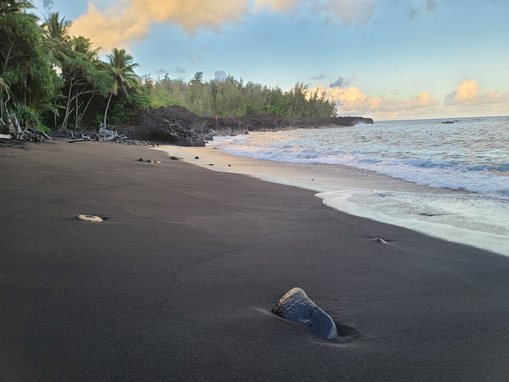
As it turned out, there the Kehena Black Sand Beach is only about a hundred yards up the road, then about twenty yards DOWN a sea-cliff. Once I had my stuff transferred from the car into the cottage, I changed and headed to the beach. There was no simple, safe way down the cliffside to the beach. Over the years, erosion and local people created, not steps in the sense of steps as we know it; but places one could put feet, hang on to the jagged lava next the path, and carefully make the way down, without falling over the cliff. I had read about the path and the difficulty, but wow!!! The last ‘step’ was about a four-foot jump to the soft black sand below. As I did this, I thought to myself: ‘how the heck am I going to get my Lard-Butt up this first step to start the climb up…. Oh well….
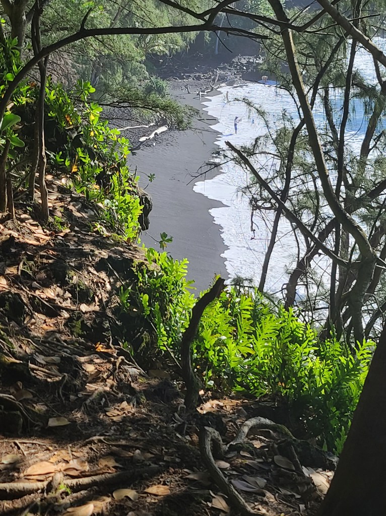
I relaxed on the beach for about an hour, as the sun was setting. The black sand, the beach at the edge of a cliff, the cliff itself being chiseled into solid lava over the years, and of course, the sea pounding on the rocks at the ends of the beach, were simply fascinating.

All of a sudden, the twenty or so folks who were at the beach when I arrived had left. Duh!! They knew to leave before it got very dark. Therefore, I thought that perhaps I should do the same. As dangerous as the path was going down in daylight, I have no idea how anyone could make it back up in the dark without killing themselves. Well I survived to live another day.
Tuesday Morning Quick Update: Morning at the Black Sand Beach
September 14, 2021
My sleeping rhythm has not adjusted even after two weeks. I still fall asleep at about nine local time, and wake up at about 4:30 AM. The five hours difference in clock time is being ignored by my body.
This morning I tossed and turned until about 5:30 AM, got up and started my normal routine of consuming a pot of coffee, while I read the San Antonio Express (online of course). I took a little walk along the tiny h8ghway in front of the cottage, then as I still was not up to full speed, opted to relax on the beach instead of heading out to Hawaii Volcanos National Park.
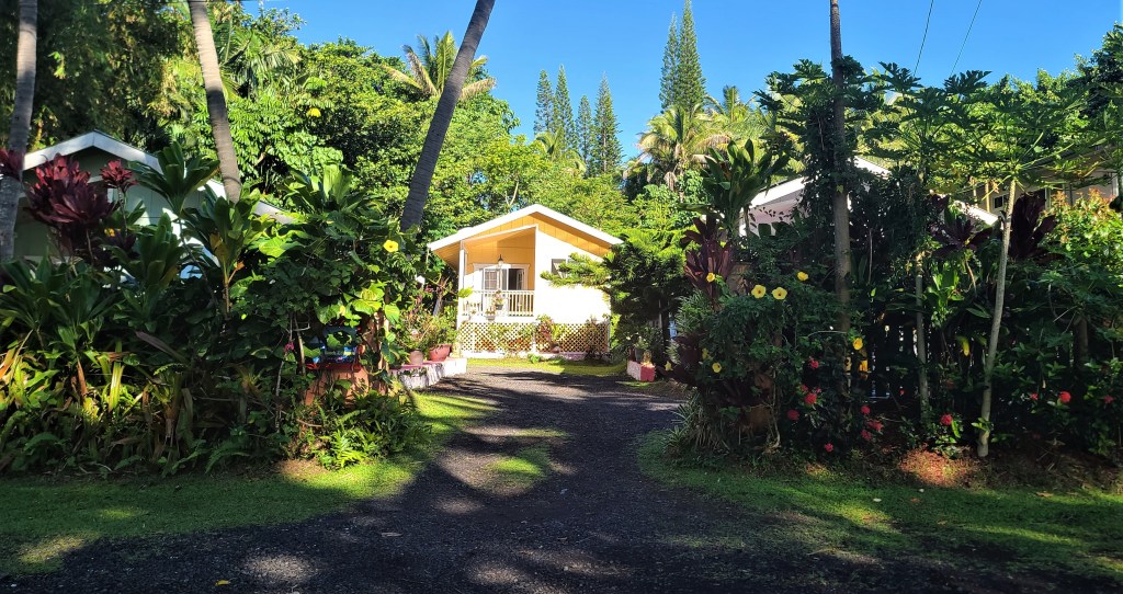
In this update I will share a few photos of the ‘cottage’ I am renting. It is basically a little manufactured home on stilts. At $130 per night, not only is it cheaper than almost all hotel rooms in Hawaii, but there is no ‘resort fees’, cleaning fees, or other crazy fees. In many Hawaiian hotels the fees often are as much as the room charge. The bonus is the cottage is 100 yards from the beach! It is quite nice, with one bedroom, a nice bathroom, living room and kitchen. There is no air conditioning, but the cool sea breezes almost made it too cool. The only down side was there were two or three types of tree frogs in the lush tropical jungle around the cottage, that thought serenading me, or their proposed mates, would be a good idea. They did make it hard to sleep, but oh well.
I took a couple of photos also across the road so you can see what I see from the little deck that I am writing this . I wrap up the photos with a little video of me on the path through the lava field down to the beach. I don’t think my dear wife could manage it, and certainly don’t think my friend Dan would attempt the climb down, then back up. The trip certainly involved using all four limbs to stay steady.
A Contrast: Nirvana to Hades, Then back to Nirvana!
Being my last day on The Big Island, I decided to checkout of my little home base, and hit the road somewhat early. First, I drove on the little road the cottage was on, Highway 137 a few miles in each direction, first east, the west. Going in both directions, I came to a point the Highway simply disappeared under gray rock. One could see part of the highway exposed at distant points as it emerged on little hills not covered by the lava.
The plan today was to drive over to the Kona region, checkout the coffee plantations, then head back to Hilo in order to catch my early evening flight back to Oahu. On the map, this looked like a simple plan, but maps to do not generally display topology of the land!
The first hour of my drive was quite pleasant, except for morning rush hour traffic in places. Driving the coastal south to north road, Highway 130, and then Highway 11 through hills in the rain forest towards Hilo was nice. This road climbs from just above sea level to about a thousand feet in elevation. Now and then one can get views of the sea that seem to be photos out of a museum. On the south side of Hilo, I picked up highway 200. This very nice road, between the two large volcanos was a good three-lane highway for the first forty miles. Two lanes were on the westbound side, the direction I was heading. It dawned on me this was designed for trucks. For about forty-five miles, with gentle curves the highway through the rain forest was UP. Again, every few miles there would be an elevation sign in five hundred feet increments. I realized the head/ear/pressure thing was happening, so now and then ‘popped’ my ears a bit to avoid getting a headache.
At about twenty-five hundred feet, the rainforest transitioned to a much less dense landscape of trees. A few miles into this, the trees looked almost black instead of the vibrant green I had been driving through. There were miles of trees like this, and it finally dawned on me, the black was from volcanic ash. A few miles past this, the lava flow began, with emerging small trees and plants scattered about.
Lava
We all have a vison of what lava is, created by short video on the news during actual eruptions, and of course from movies/TV drama. We see this hot red glowing rock moving, constantly moving towards the see, giving off steam, and ‘wanting to destroy’ humans. Unfortunately (or not) I didn’t get to see flowing lava or magma. There are a few helicopter tours that take folks over one or two of the calderas where one can see molten lave deep in volcano, but time and expense (Starting at $335 fora fifty minute flight) made this a non-starter for me. I did however get up close and personal with lava, the cold and hard kind.
As I came to learn, there are about dozens volcano cones/mountains that make up The Big Island. Some of these are simply small hills one can see as you drive around, where eruptions occurred over time. Kilauea is the volcano most of us have heard about, as this giant caldera is the one the national park is built on, and the name resonates. Kilauea is actually about the third in size as compared to the much higher, and now much more active Mona Kea, and Mona Loa. As compared to Kilauea at just over four thousand feet high, Mona Kea and Mona Loa top out at over thirteen thousand feet or about two miles above sea level.
State Highway 200, the main road also known as the ‘Saddle Road’, was built almost exactly between Monea Kea and Mona Loa. As such, one gets to know the true meaning of lava flow and lava field. There are a few things our conception of lava in no way grasps the actuality. We know of to porosity of ‘lava rock’ as we buy bags of the stuff at our local hardware store for the flowerbed or gas grill at home. Nevertheless, for a moment think about six to twenty feet of this stuff covering your home, your neighborhood, and miles around you! The hundreds of square miles covered by lava on both sides of the highway, as I drove between the two giants, struck me! The lava had hardened in a much different way we might think. The lava field is very irregular in height, not the smooth field of rock we may see on TV AT times the lava may be crunchy gravel under your feet, but nearby multi-ton boulders of the stuff. Between those two extremes are little piles of the stuff from two to ten feet high. To build, and I am sure rebuild several times, highway 200, I suspect the state simply used heavy equipment to plow a flat path through the lava fields. Two different times I drove ten to twenty miles across terrain that was nothing but jagged lava fields. The landscape is quite stark, with the gray (or reddish or black) lava EVERYWHERE. A few trees or bushes could be seen now and the trying to return the area to normal soil. One can almost imagine (if somehow you could survive) the hellish nature of 2,000-degree molten lava, steaming as it moves across the entire visible land. Within a few miles of driving through this stuff, and once the amazement wears off, the stark grays become a bit boring. The greens of the slopes of both volcanoes, the winding of the road up and down the slopes, and around curves, does make it an interesting drive.
The last forty miles of the drive to Kona takes an interesting, if not pleasant change (at least for the driver). The nice three-lane road comes to a dead end, after driving through miles of semi-desert land and small mountains west of the giant lava fields. This reminded me of driving through the desolate areas of northwest Texas. Scrub brush, dirt, rock, and generally dry. There is simply no human related structures out here, except for a small US Army training facility of some sort, a few huts near the cutoff road for one of the volcano tour centers, and the occasional small structure. No people, no stores, and no gas stations. This really boring part of the drive, sets the driver up for the next forty minutes of ‘white knuckle’ driving. Not since my driving in the hills of Tuscany, Italy, or driving the roads of the Greek Islands, have I driven in such an unsafe and exhausting area.
As the nice Highway 200 comes to a dead end, you turn left towards Kona. At this point, for the first time in two hours, one can see the sea……far below. I actually got the perspective of flying in an airplane, and the sea and coastal towns were two to three thousand feet below. Like on the mainland, the road now followed what was probably a path across and down the mountainsides created by natives or traders long ago. The road twisted, curved, climbed and dipped for forty miles. The common theme to this is sharp drop offs on the west (passenger) side of the road. There were a few places; one could see sites of accidents, down the hill a bit. The rusty hulks of cars remained, as I suppose it would have been too dangerous or impossible to recover them. Now and then ‘scenic view’ places were on the side of the road, but these were so narrow, that I decided not to take the chance of a wide truck going down the very narrow two lane road would ‘bump me’. Now and then, I would take a glimpse over to the ocean. It was of course wonderful. The dark blue of the ocean became almost light green as coral reefs dotted the shore. I was still, even as ‘the crow flies’ ten miles from the shore, and God knows how far up, at these points. Reaching a lower elevation, the road finally emerged from desert like setting to lush trees, but it remained treacherous driving or the last five miles going into the city of Kona. The steep hills and cures remained all the way to the lateral road running along the sea in the tourist area where a flat road was finally for the most part.
By the time I reached the tourist district of Kona, ‘mother nature was calling’, I was exhausted, and even though I had consumed mass quantities of junk food snacks as result of boring drive through the lava fields, I was hungry. After driving a bit through the twenty blocks or so of tourist area along the seashore, I found a parking lot, and then walked to the shore to explore a bit. Crowds were somewhat light, as Hawaii has increased requirements of safety this week, due to COVID. I found a nice restaurant with outdoor seating next to the water. There were few folks eating so I just too my time enjoying an expensive but quite good fish and chips lunch. As I was facing another tense drive up the mountains on the crazy road, I spent time on the Google Maps smartphone app to find an alternate way back to Hilo. At this time I still had five hours before my flight to Oahu from Hilo, so could take my time. I quickly discovered Highway 19 circled around most of the north end of the island then back down to Hilo. Off I went. Once clear of the tourist area, and general part of Kona, the road entered another lava flow. The road for the most part ran up on the mountainside, but only a few hundred feet. In addition, the road was very nice and wide. This allowed great views of the both the sea and land. The lava flow, of which some was in recent years, again was miles wide and miles long. I do not know the geologic reason, but most of the lava here was a rusty red instead of the gray shades of the other lava fields I drove across in the morning.
After about thirty miles, driving almost due north from Kona the road came to a dead end. Highway 19 now turned inland to the right. The next twenty miles, again was climbing up from sea level to high in the mountains, with Mona Lea on my right and smaller volcanos on my left. The road was just as curvy and hilly as the other road, but as it was much wider, and the land being much softer slopes, it was a nice drive. Trucks slowed traffic down now and then, as they tried to climb up the slope, but even these found wide spots they could pull over to allow cars to pass. On this highway, there were several small towns. As the road reaches a peak, perhaps twenty-five hundred feet above sea level, the desert type land gradually became greener, and then light forest appeared. One little town on the edge of the forest reminded me of mountain towns in Colorado. The air was crispy cool due to the altitude, and the place just looked pleasant. After this town, it was obvious I was on the windward side of the island. The remaining seventy miles or so of driving was through dense rain forest. Deep greens of the forest floor being towered over by tall straight, almost white barked trees probably a hundred feet tall. Now and then where a river flowed through a mountain valley requiring the road to cross it near the sea, the road would take a giant ‘U’ curve on the mountain side. The speed limit of these was maximum of 25 MPH, as the road sharply curved, angled downhill for a bit, crossed the river, and another short curve climbed back up the mountain side to resume the path south towards Hilo. This occurred four or five times in a stretch of about fifty miles. At the river bridge of each, instead of being a sign for the river name, there would be the name of the ‘gulch’, as in Hanna Gulch. If you ever drive this road and have a passenger, have them shoot a video of the mountain valley. From the few glimpses I had they were each beautiful.
The last twenty miles I drove through a pounding rainstorm, so my full attention was driving. As I entered the north side of Hilo, the rain stopped. I had a couple of hours before my flight so explored the coast line of Hilo’s harbor area. After half hour of this, I checked in the rental-car, and was pleasantly surprised to be able to change to a flight an hour earlier than I had booked.
This was the end to a jammed packed two and half day trip to The Big Island. I had driven through three of the four coasts, driven by or visited three of the largest volcanos, and enjoyed a black sand beach. The two largest cities and tourist areas of Hilo and Kona were very different in contrast. Hilo with its slower vibe in the middle of a coastal rain forest, and Kona, with its ‘happening’ tourist town vibe, located between mountainous arid country and beautiful sea. To be honest, I did not travel south of Kona into what I think is the coffee growing region, but from my perspective the Hilo area would be my choice of places to prioritizing visiting. I suppose if I were much younger, and much more interested in the face paced party environment of tourist towns, Kona would be my choice. But it is the laid back, beautiful green windward side of the island that stole my heart. I would live here if I could afford it, and certainly would love to spend a week or more on the rain forest covered hillsides.
I hope you enjoyed my journey to the ‘Island of Hawaii’ (The Big Island), as much as I enjoyed sharing with you. Now for a day of rest, a late afternoon snorkel trip at Makaha beach with neice Rachel, and one more day tomorrow to enjoy Oahu. Saturday, the big bird will carry me back home to my family and dogs in Texas.
The Sleeping Child of Pele (The Goddess of Fire)
When driving on any of the Hawaiian Islands, one is constantly reminded of the underlying reason the island exists. The islands are each large mountains in the sea that were created by ancient volcanos, with the exception of The Big Island, or Island of Hawaii. In the case of the Big Island, the creation and growth continues with periodic eruptions of one of the two larger volcanos on the island.
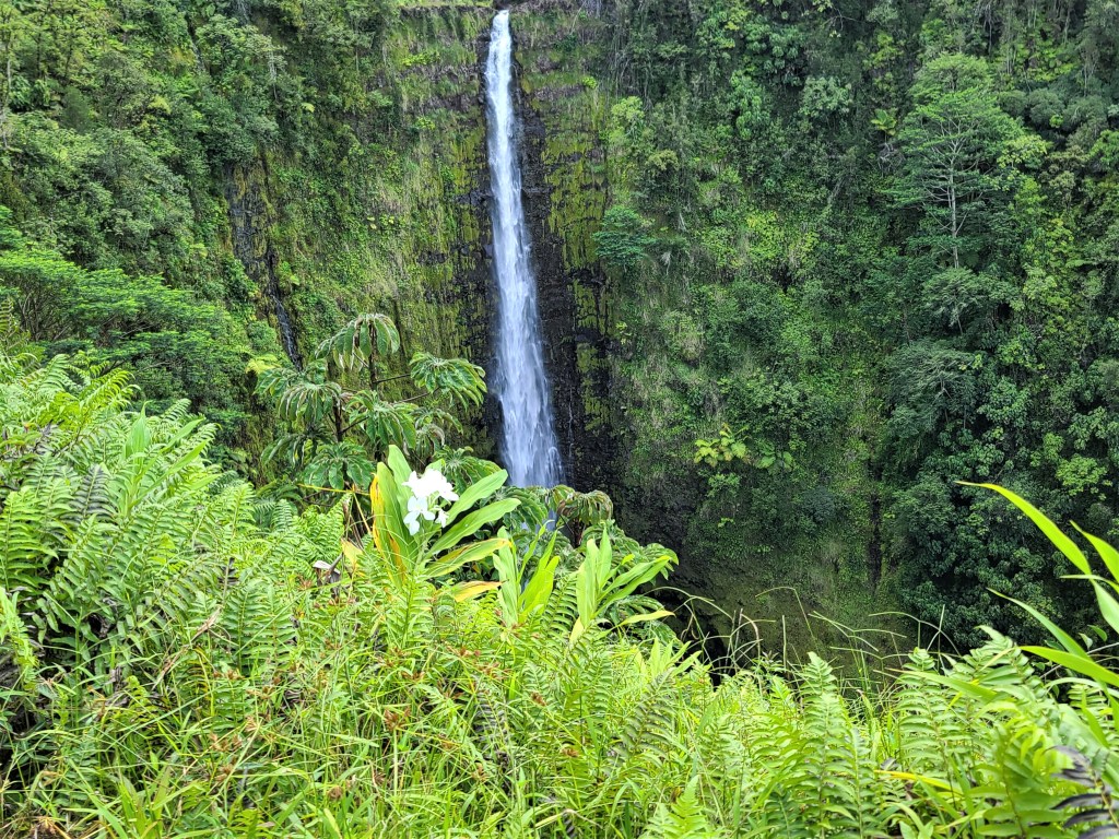
Tuesday afternoon I took the thirty-five mile drive from my cottage on the southeast shore up to the Hawaii Volcanos National Park. With a bit of traffic, the drive took just over an hour. The very good highways took me through very dense rain forest, a green pleasant drive. I kept getting the feeling I was climbing until I started seeing road signs every mile or two indicated the elevation. The last twenty miles, on the road up the gentle slope of Kiluaea was about twenty miles. In this distance, the elevation increased from about five hundred feet above sea level to four thousand feet! All of a sudden, I was at the entrance to the National Park.
The Hawaii Volcanos National Park Visitor Center was located the edge of the rain forest with no hint of a volcano anywhere near. The visitor services was curtailed due to COVID, so I was disappointed the movie introducing visitors to the park, was not running. There was however a very well-spoken park ranger giving talks and answering questions in front of giant aerial photos of Kilauea.
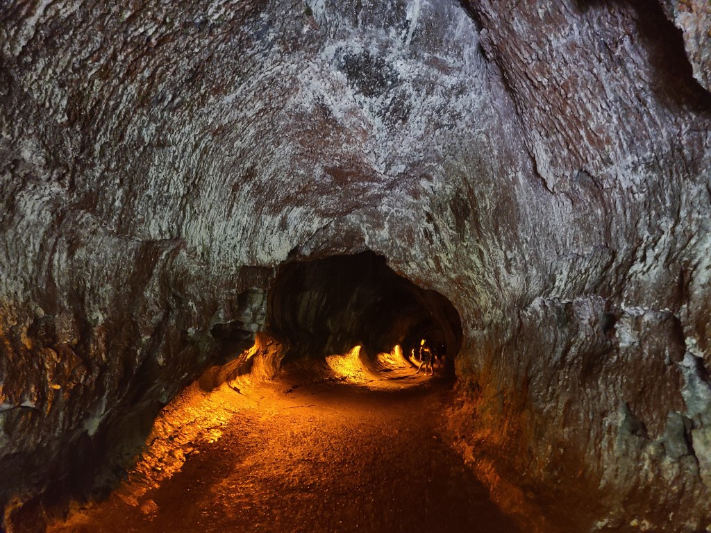
One of the things he share with us is that the eruption in 1968 (?) created a large lava tube that ran twenty four miles before opening up and spreading molten lava over a large area of the southeast coast. This of course explained to me all the lava coating the area I am staying. In the photos today, you will see me walking through that very lava tube for about half a mile, as the park service has opened it up. You will also see the results of the lava flow over in the neighborhood next to the sea. Driving down state highway 137, all of a sudden gray walls on either side of the road appear, the road turns into gray gravel, then a bit more highway until a mile later the highway disappears under miles of lava.
The lava photos show a few interesting things: It shows both nature and man’s determination to survive. You will see small trees and plants growing out of the lava, and houses scattered across the lava field. Folks who owned land here, apparently are reclaiming their land and building small homes, where homes destroyed by the lava flow years ago.

Back to the entrance to the park: As I left the visitor center in the direction the park ranger told us to drive, I was struck with the rain forest around me. Driving west a few miles to the observation point, the forest was as if nothing of danger lurked nearby. After a bit I drove through a little valley where steam was coming out of the ground in various places. This of course is from rain water seeping far below hitting molten lava, thus producing steam.
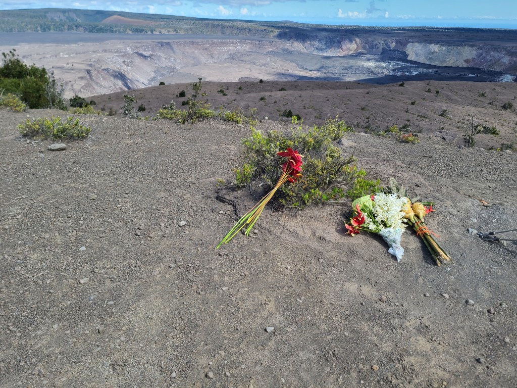
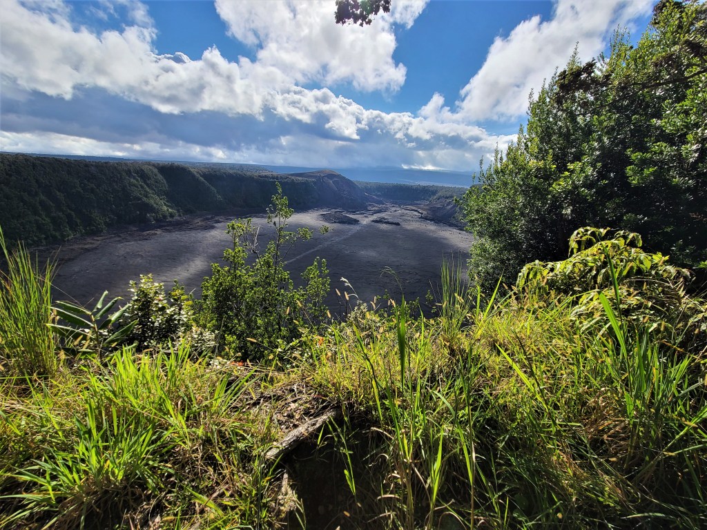
After a bit, I reached the park road dead end at an observation point high above the crater. It at first was much less dramatic of a view than I expected. Then it dawned on me how dramatic the seen below me actually was. The crater itself is probably over a mile wide, and three miles long. The ‘floor’ of the crater was a least five hundred feet below where I was standing. One could see ripples and cracks in the broad flat floor that are results of the periodic small earthquakes as magma (molten lava) continues to move around underground. Then there is the caldera; the deep GIANT hole down to the level of the molten lava. The edges of the caldera was angry blacks, grays, and shades of white. Of course being at least two miles from it, we could not look over the edge to see the actual magma.
The shear size of the volcano gives one the ‘willies’ knowing the thing is active, and still ‘blows it top’ every decade or so. The park ranger assured us they monitor several things to make sure we are safe. Before an eruption apparently several things occur: Many earthquakes at increased frequency indicate the magma is on the move. They monitor for increased venting of gasses; steam and other more dangerous gases, and apparently the actual slope/height of the of the area of the next eruption grows in the days and weeks before the event. He told us that during the eruption and lava flow in 2018, folks had been given about a two week notice to evacuate.
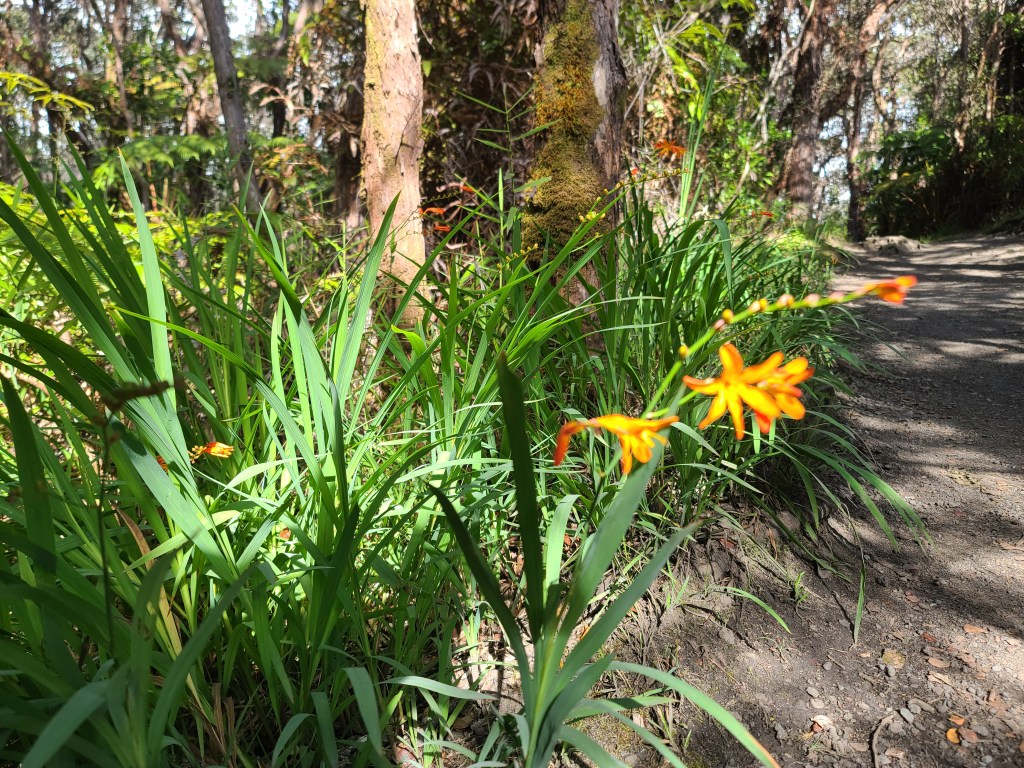
The day turned out to be a really good day! As I shared earlier, my day started with a couple hours down at the beach, then the drive to the volcanos. I will have to poke fun at myself a bit…again, I am not ‘the sharpest turnip on the truck’…LOL. So I reached the parking lot for the lava tour walk. There was a trail for a one mile walk along the rim of the crater to the entry point to the tube, or a half mile walk. You guessed it: I made a mistake and took the long route…DUH! So a mile walk each way to the entry point, then DOWN a fifteen minute walk on gently sloping sidewalk and steps. This took me to the bottom of the deep rain forest. Then the half mile walk through the lava tube, then the walk back UP to the top, then the mile walk back to my car…..I was TIRED! This 70 year old body got a work out for sure!! You will see however the walk was not in vain, as I got some nice photos of nature. The little tropical yellow wild flower you will see kept catching my eye. These are everywhere! Something of such beauty being displayed by nature sort of randomly, makes one happy to be alive.
To end this long product of my fingers on the keyboard, fueled by three cups of coffee, and a pack of those little chocolate cover ‘donettes’, I have a short story to share.
About halfway back to the car, along the rim of the crater, I walked by a downed tree. It caught my eye, so I turned around to look closer. This tree had been knocked down by the forces of nature, perhaps shock wave from the last eruption. Half of its root system was exposed to the elements, yet half were deeply planted in the earth. What is amazing is three or four tree trunks rose from the horizontal original trunk, getting their life through the original root system. These trunks look as healthy as their parent tree.
As I looked at this scene, it reminds me of our lives. We are all rooted to this earth through our parents. We grow from them and take sustenance from them. As our lives develop, we can grow as straight towards the heavens, or get sidetracked and wither. There are things that have and will knock us down, but if we stay connected, with a lot of love, we will live happy lives. In the end we are all part of this thing called life, and now and then should be reminded of the blessings of nature that our God bestowed on us. It is up to us how to grow.
Hawaii- Its People and Contrasts
I have been in Hawaii for four days now. Oahu where I am staying is an absolutely beautiful place. The lushness of the mountainside jungles on the windward side (east), contrasts with the arid leeward (west) side of the island. Mountains dividing the island are very high, and provide unique views depending on which side of the mountains one may be. The shoreline around this enchanted place of course is the beautiful sea with its contrast of greens, black, blues, as determined by water depth and reefs. The shoreline is a mix of ancient coral or lava flows interspersed with white sand beaches. From a visual perspective, one could not find a more ideal place. As most folks visit the islands, all they usually see are these scenes, with the focus and exposure of the population carefully calibrated to ensure the visitor has a great time, and that a maximum about of dollars flow.
Since mainland Americans established first plantations in the 1800s, then large military installations, Hawaii has been a melting pot on steroids of different ethnic groups. The ‘native’ Hawaiians were peoples of Polynesia who settled the islands between 200 and 1000 AD. As first British and then Americans started creating large plantations in the early to mid-1800s, the need for cheap labor resulted with many people being brought from Japan, Korea, China, The Philippines, and some European nations such as Ireland. Like mainland America, these new peoples outnumbered the ‘natives’ by the end of the 1800s. It is not commonly known, but by the early 1900s, approximately twenty five percent of the population was from Japan, or Japanese descendants.
Over time, marriages between different nationalities produced the Hawaiian population of today. The majority of the people, perhaps as much as eighty percent of the population, have mixed Asian background, while at the same time many Caucasian Americans, both military members/families and wealthy, along with a sliver of the original native population, provide an interesting mix of citizens.
Like many place in the United States, and the world at large, Hawaii has a contrast with social economics. It is a bit more pronounced here, as the cost of living is astronomical. There are many homeless people living in tents or shanties near beaches, sometimes only steps away from beautiful tourist beaches. Many of these folks work as other people do, and other than not having a permeant shelter, live as others do. As with any homeless population however alcohol and drug use, along with some mental issues, the challenges are the same. Living conditions vary greatly. Modest homes just as a three bedroom, two bath that sells for about $300,000 in Texas for example would start at about $825,000 on Oahu. The population seem to be trapped between the very high cost homes with modest yards, wealthy estates and ranches for very high-income families, or very small homes on property handed down through generations of families, divided then divided again by family members. On some small properties, six to ten homes of a given family can be found. Many of these owned by proud families are little more than shanties.
Most goods such as hardware and food are imported to the islands. As a result prices run from thirty to hundred percent more than the mainland US. This of course adds to the stress of people with modest of no income.
Like many places in America, and the world at large, COVID is a challenge to Hawaii. About sixty-five percent of the population have been vaccinated, but the unvaccinated illness is spreading rapidly. The Hawaii government and people are quite challenged about what to do with tourism during this pandemic. Tourist bring about eighty percent of the revenue of the state of Hawaii. A large amount of jobs in the state is tourist related in some form. There is a conflict about cutting of tourism, thus the revenue flow VS keeping the state safe. The Hawaiian government created a system known as Hawaii Safe Travels, to help ensure tourist are either tested for COVID or verification tourist are fully vaccinated. Masks are required almost everywhere. An interesting precaution is required in restaurants. As one enters a sit down restaurant, temperature is taken, the patron is reminded mask are only allowed to come off when actually drinking or eating (not while relaxing and talking), and a name and phone number in each dining party is required to be logged by the host/hostess. This information would then be used to do contact tracing should COVID cases be reported.
The intent of this musing was not to be negative, or dissuade anyone from visiting. It is intended however to remind the reader to look beyond the beauty of the place, and the tourist view. One will find that Hawaii, with all of its beauty, is like any other place in America. Folks love their families, work to provide for their families, and the normal issues of life, yes even struggles with COVID, are the same as we face anywhere in America.
Blessings of Housing
As I start each morning while visiting this magical island, on the back patio of my host’s home, I see lush tropical vegetation. Tropical fruits such as guava and papaya grow from neighbors trees. Beautiful birds can be seen and heard. Drinking my wonderful Kona Chocolate Macadamia nut coffee is about as good as it gets. I have the great home of our nephew and his wife to stay in, and of course, we have a nice comfortable home on thirty-five acres of wooded land back in Texas.
As I was driving the few miles north last evening to watch the sunset over Makaha beach, I drove by the large fifty-acre or so wooded homeless community next to the Wainae City Boat Harbor. Along the highway that curves along the seashore at the base of beautiful mountains, individual tents or shanties of homeless folks, periodically could be seen in the rocky areas of the coastline between tourist beaches. A few days ago, while exploring the southern areas of Oahu, I noticed signs to deter homeless folks, with bold letters under freeway bridges: ‘No Camping Allowed, Removal Enforced’. It so happens this section of freeway was at the edge of the famous and expensive Waikiki Beach district.
Increasingly as we drive in the large cities of America, we see the plight of the homeless. Seattle has been coping with the issue for decades, as has other large cities such as Los Angeles. Where a decade ago, one could drive around Austin, and except for a few isolated areas, one would not see homeless folks. Now driving in Austin or San Antonio, makeshift shelters can be seen quite often under freeway bridges. This phenomenon has now spread to smaller and smaller cities and towns.
It is very easy for us folks who have a warm/cool bed to sleep in at night, clean water to drink and bathe in, and shelter from the elements, to look down on the folks who are homeless. Actually, it is way too easy to discard them in our thoughts. At times, we may actually fear them or resent this folks, who are at the essence humans like ourselves.
Yes, some of these folks may have deep psychological issues, some have fell into the despair of drug and/or alcohol abuse, some may be veterans who were not able to cope with PTSD, and others who simply have fallen on bad economic circumstances. Some folks simply, for a number of reasons, want to live a life outside of a structured society; perhaps desiring to remain anonymous for any number of reasons.
In the end, again, these folks are humans like each of us; they just live differently. Perhaps when we see these folks, instead of revulsion or fear, we should say a little prayer of thanks for our own ability to live in whatever home we do. Perhaps in that prayer we should ask our God to bless these folks. In small ways, we could help these folks now and then. I am not talking about providing pocket change for the scruffy gent and his dog sitting at the stoplight of a busy intersection. Instead, perhaps we could find charitable missions that cater to these folks, and provide normal things they could use. Decent clothing, toiletries, and yes food. We may not be able to move these folks back to ‘normal’ lives, but we can provide things that can help them live as we do. Remember, each of us, or one of our loved ones, at some point in time, from an unfortunate circumstances, could be one of these folks ourselves.
Help as you can, but at least keep in mind that these folks are also God’s people, and lets treat them as such. Your heart will be warmed as you do, and remember now and then, a prayer of blessing for these folks.
Farming In Hawaii
As one drives to explore the beauty of Hawaii one thing comes into focus: the deep red volcanic soil of farms. Most farming done on the islands is done to produce food products. This has been the case since the Polynesian people settled the islands somewhere between 200 AD and 1000 AD. These people brought plants we are familiar with, and others we are not. Sweet potatoes, yams, bannas, coconut, sugar cane, turmeric, pigs and chickens, are or course things all of us are familiar with as foods. Other things such as taro, edible ‘elephant ear’ plants, breadfruits, and mountain apple are staples of the Polynesian diet we are not usually familiar with.
In the early 1800s American and European settlers brought the first cattle, pineapple, and coffee to the islands. As the 1800s ‘progressed’, western settlers found ways to take lands from the native people to establish large plantations and ranches. Giant sugar plantations feeding the sweet tooth of the U.S. mainland, dominated farming. Plantations of pineapple, while large were a distant second in crops. Local growth of native foods and western vegetables, of course continued to be cultivated. Until around the time of World War II, Hawaii was self-sufficient in food production.
Agriculture brought many changes to the islands in the last half of the 1800s, and first part of the 1900s. American business people found new ways to ‘acquire’ land to increase the size of plantations, eventually causing the Hawaiian royal families to capitulate, and give up most traditional family lands to western people. By the early 1900s, American legal system dealing with land title and ownership, found most raw land ‘owned’ by non-native people with roots in the US mainland, if not by giant American corporations.
Socially, the period of plantation expansion from the mid-1800s, well into the 1900s resulted with an extreme shortage of workers. Large recruiting efforts, many with false promises of land ownership, in Japan, China, The Philippines, and other Asian countries. As famines broke across Europe in the early 1900s, recruiting there brought many groups of Irish and other folks to Hawaii to work the plantations. Over the decades of course, as with most areas of the world, folks from different ethnic groups co-married. Today, Hawaii is about eight percent mixed population with Asian descent. There are relative few members of pure native Hawaiian descent.
Today, as one drives across the lower coastal areas, mountain valleys, along rivers, or areas higher in elevation, but not quite mountains, large fields can be seen in various state of cultivation. The highway to Oahu’s ‘North Shore’ is great example of this. On the leeward side (western) side, one can see rolling fields of sugar cane in production. As the gentle pass through the mountain ranges is passed, one can start to see giant rolling fields of pineapple being cultivated, in various stages of its three-year growing life. Of course this is where the interested Dole Pineapple tourist center is located. As one approaches the descent from the hills towards the north shore, and sea level, the road passes through an unlikely area of very tall fir trees appearing as if they are tropical pine trees. These trees are perfectly aligned, with large spaces between square boundaries of the trees. If one looks closely between the trees, coffee plants can be seen in acres size fields. The writer can’t explain this, but perhaps the trees are planted around the coffee fields to break the trade winds which constantly blow on the windward side of the island.
On the northern island of Kauai, especially on the north side of the island, near the area known as Princeville, one can see extensive fields of taro. This potato like tuber vegetable provides starch in the native Hawaiian diet. Taro is used in many products from making flour of sorts, to chips. It is mixed with many other foods to produce nice local dishes.
Coffee of course is the largest cash crop on the Island of Hawaii (also known as ‘The Big Island’) The northwest corner of the island with the town of Kona, gives the name to Hawaii’s well known Kona coffees. Macadamia nuts of course, are well known and contribute much to the agriculture economy of Hawaii.
Today, tourism long ago eclipsed agriculture as the drive of the Hawaiian economy. Agriculture, both land and seafood, has been reduced to less than ten per cent of total economic impact on the island. Over the past fifty years, the combination of tourism, and its impact of soaring land prices, and the chronic shortage of labor to work the fields, have combined to shrink the agricultural environment. A perfect storm of extremely expensive housing, very high taxes resulting from astronomical land value inflation, and simply better jobs in the tourist and military support areas, all impact the availability for labor in the agricultural space.
In closing, as you drive around the magical Hawaiian islands to explore, stop now and then just to relish the view of farming that is somewhat the same, but also different than we are used to on the mainland. Stop and a farmers market of simple roadside farm stand to sample the wares. Try foods you are not familiar with such as mangos, papaya, dragon fruit, etc. Of course do enjoy the things we all love such as pineapple, of which is not sweeter anywhere else in the world! At least once in our visit stop at little fast food joints, like the chain of L&L BBQ joints. This is not your Texas Barbeque, but Asian fast food. In restaurants try local seafood dishes; your palate and tummy will be glad that you did. In the end, make learning about the foods of Hawaii and the growth of the, part of your memory to this exotic part of our nation.
Driving in Hawaii
All of the Hawaiian Islands have one thing in common: they were formed, and in the case of The Big Island (Island of Hawaii) still being formed, by volcanic activity. Each of the islands have mountains, multiple volcanic cones, and many river valleys.
Historically, before western man came to the island, most transportation was by water. For lack of a better word, ‘tribes’ or extended groups would settle valleys by rivers. The population were spread up and down the valley from mountain to the sea. Visiting, working, trading food, etc, were done on the river. Visiting or trading with others similar groups would mean sailing by sea to other nearby river valleys or other islands. Some islands have lower central elevations, yet still quite above sea level, so paths overland did some intermixing.
As westerners started settling the islands, they found other ways to travel. In addition to travel by water, trails, roads and even railroads were created as westerners built plantations around the islands.
Fast forward to today, and the modern road system, is not unlike what we saw in Tuscany when we visited Italy about then years ago. There are few straight or flat roads on the islands of Hawaii. I might not be correct, but I think the island of Oahu contains the only true freeways in the state. The longest of these is the approximately thirty mile long H1 on the south and west shores of Oahu. The H2 freeway runs from Pearl Harbor north to the Scofield Army base at a length of about twelve miles. The H3 runs from the Pearl Harbor area, due east about twenty miles. It terminates near a large Marine base on the east shore. The H3 is the most beautiful of the three as it runs through a lush river valley towards high mountains, then a tunnel through the mountains. As it exists the tunnel at a relative high place on the mountainside, the view of the eastern shore is magnificent!
Like in any large metropolitan city, and Honolulu is one, the freeways can be quite ‘interesting’ at rush hour!!. What makes rush hour even more of a challenge’, is all the freeways simply end and become normal state highways. This includes miles of traffic lights, which back traffic up on the freeways during rush hour.
Driving on state highways around the islands requires the driver to be alert. Many of the roads contain blind spots, drop-offs, and simply natural dangers such as falling rocks. In areas of schools, small village areas, and certainly in beach areas, one has to be aware of folks walking across the road. With the exception of freeways, the usual maximum speed limit is 45 MPH. In areas such as schools or small towns/neighborhoods the speed limit with be posted at 20 or 25 MPH. Some of the higher trafficked areas, such as popular beaches can be dicey. At certain times of day, traffic moves quite well, but at times it moves at a snail’s pace. On one afternoon I drove east on the Oahu North Shore road. The first eight miles moving east took me about twenty minutes. Coming back the same route later in the day, the same eight miles took me almost an hour.
Speed limits are almost universally ignored by locals, but every day state and local police write many tickets. This is especially true on the Oahu freeways. The police have a ‘special place’ in their heart for tourist driving Hawaii roads and speeding.
Often times roads, especially the freeways of Oahu, are built elevated. In the area of downtown Honolulu and near the airport, this is done as the amount of land for roads is scarce. Local traffic usually run on streets under the freeway elevated deck. In many areas the mountains almost meet the sea, so small strips of land is flattened to create the road/freeway. Often times this creates fantastic views of the sea, mountains, and valleys. The driver however must stay alert to traffic, and not the views. As the roads hug the hill/mountain sides, the roads wind around the shoreline. This can create an illusion of a point one can see, being actually quite close. There is a place that downtown and Diamond Head looks only a few miles from the west side, west of the H2. In actuality downtown is about twenty miles away because the freeway winds in and out due to the mountains. Due to roads running around mountainsides, one can be heading to a northern location on the island, and at times be driving due south.
Caution must be used on secondary roads for several reasons. Portions of the islands are in extremely poor areas, so crime can be a factor. On some country small roads, sadly folks dump large trash items from mattresses, bags of trash, even junk cars or appliances. On some country roads, what seems like a simple, but blind cure can in fact be a very narrow curve on a Cliffside road, with very little protection once around the curve.
Driving in neighborhoods can be quite a ‘game’. With housing prices extremely expensive, even upscale neighborhoods have very narrow streets. As the cost of housing and cost of living in the islands is so expensive, a given house might have two to four families living there. This can result with multiple cars. You will find cars parked on both sides of the street, with barley enough room for one car to navigate. If you see a car coming your way, either as a courtesy or the ‘game of chicken’, either you or the on-coming car will need to pull over a bit for one of you to pass. Children in these neighborhoods tend to plan in the street, as home yards are quite small. One must always be alert for kiddos in the street, or at the last moment running into the street.
To summarize driving in Hawaii, I suggest you do rent a car, and explore whichever island you visit. If possible plan your path of exploration, before you get in the car. If possible have a ‘navigator’ in the front seat with you, using a modern mapping app, such as Google Maps. By careful planning, and staying alert, one can find ‘secret’ little areas of Hawaii beauty stuck in the most unlikely places. Just be aware, and alert, and your Hawaii driving will be great!
Hawaii and COVID-19
Please note: Nothing in this musing is intended from a political slant. This writing is intended to help anyone who may want to visit Hawaii between now and the end of the COVID epidemic enjoy Hawaii without being quarantined.
COVID is not quite yet bad as it is back home in Texas. It is getting there, but not quite yet. The Hawaiian state government is extremely proactive however. They are struggling with their economic lifeblood, travel and tourism, which provides about eighty percent of cash flow and jobs in this state consisting of eight main islands. They have to balance this with the safety of the folks who live in this wonderful place.
Over the past months, the Hawaiian Government has created a program called Hawaii ‘Safe Travels’. If you want to visit Hawaii, you MUST register on this system. Safe Travels provides a traveler with three options, if the person wants to visit Hawaii:
- Register, and then get certified, that you are fully vaccinated
- Have a NEGATIVE COVID test from a Hawaiian approved testing site within a given period of time. (testing sites are listed on the website; for example there is one at the Austin, TX airport.)
- Go into two week quarantine; knowing you must report in each day via internet during your being stuck indoors at a home or hotel.
The state is aggressive for looking at cheaters to the system. They have arrested, thrown in jail, and gave heavy fines to a few folks from the mainland for falsifying documents.
One can agree or not agree on this system/requirement, but if you want to visit Hawaii, there is no choice.
The official Hawaii Safe Travels information, and sign up can be found at:
There is a little two minute video on the page explaining the program and registration starting points. I did this in about twenty minutes, attained my ‘QR Code’ the day before I flew out of Austin, and the process was a breeze after that.
Yesterday, Tuesday, August 31st, the Hawaiian State Government announced emergency orders that steps up requirements to enjoy the state. Starting September 13th, proof of weekly negative test, or proof of being fully vaccinated will be required BEFORE one can go inside a normal sit down restaurant, café, or fast food place. This also is in effect for other places such as gyms, theaters, some tourist attractions where a number of folks are in close quarters.
So far, since I did do registration, and have had my two original vaccination shots, plus the third booster shot, things are pretty much normal for my current visit. The only thing I have seen that is different is some fast food places have completely closed their inside eating area, and mask are required EVERYWHERE!
If you plan to visit Hawaii, get registered with ‘Safe Travels’, and enjoy your visit!!! I sure am enjoying my time here.
Musings from the Stevens Ranch (Evening in Waianae, Hawaii)
Oahu: Valley of the Temples – Kaneohe, Hawaii
Today I decided to drive to the east side of Oahu. Niece Rachel had told me there was a beautiful Buddhist Temple near the town of Kaneohe. I had seen mention of The Byodo-In Temple in tourist pamphlets while visiting Oahu several years ago. So this morning with my friend Google Earth, I planned my day. Underway the Google Maps app on my trusty Samsung smart phone helped me navigate.
There will be a few places in this musing that will drift away from the temple a bit, so stay with me.
The Journey
My trip started just after noon, with a stop at the locally owned convince store. I filed the car up with ‘cheap’ $4.00 per gallon gas, and purchased a small bag of ice for my cooler of water and Coke Zero. (Long ago, I tired of paying three bucks a can or bottle of coke). Finally heading south on the highway, through eight miles of stop lights, past beautiful west side beaches, and of course the fairly common homeless camps. As this coastal road runs along the sea, often a couple hundred feet up the mountainside; the view of the Pacific is just awesome. After the first eight miles, the highway simply becomes the major freeway on Oahu, the H1. I continued on H1 with its six to fourteen lanes down to Honolulu. Again, after a bend around one mountain, the entire city of Honolulu comes into view. From Ewa, through the three branches of Pearl Harbor, past the airport, the downtown skyscrapers, then on to Diamond Head, distance is elusive. As the crow flies, the distance is about five to seven miles, but as the road winds around the edge of the mountains and sea, the distance is actually about twenty miles.
Picking up the H3 freeway (intrastate highway) in downtown Honolulu, it only takes moments to travel via a long winding river, through dense rainforest deep into a mountain valley. Think the mountains you may remember in the Jurassic park movies….these are those mountains. The H3 winds up into the mountain valley, as the road climbs continually to about thirteen hundred feet above sea level H3 enters the Tetso Harano Tunnel. The tunnel runs just under a mile length through the mountains with a slight curve.
The exit of the tunnel is what makes this my absolutely favorite stretch of highway I have ever traveled. The vista makes it insanely difficult concentrating on driving. The view of the blues and greens of the ocean, with little islands mixed in, with the steep rain forest covered slopes of the mountains you just came through is breath taking. At the point of the tunnel exist one finds themselves still over a thousand feet above the sea, so the visual effect is as riding in an airplane at a low level over one of the most beautiful seascapes in the world. My only disappointment there are not pull over areas one can enjoy the view or take photos
If you ever visit Hawaii, and are on the Island of Oahu, even for one day, there are two things you MUST do! Visit the historical Pearl Harbor Museum, and drive the H3 Interstate from Honolulu to Kaneohe. As you enter the tunnel, make sure whomever is in the passenger seat gets a camera ready, and slow down as much as you safely can as you approach the tunnel exit….and driver…don’t forget…there are about two miles of extremely steep and winding road before you can relax a bit.
The Byodo-In Temple
As it turns out the ‘temple’ is actually a reproduction of the original temple located in the city of Uji in Kyoto Prefecture, Japan. The temple here is located in a giant beautiful cometary located high on rolling hills at the base of the mountains. The area is called the Valley of Temples for a reason. There are a number of sections, gardens, terraces dedicated to different religions. Each of the larger sections has a temple dedicated to the specific faith of the area. The Byodo-In Temple of course is dedicated to the roughly twenty-five percent of the Hawaiian population who are of Japanese descent. This reproduction was done in 1968 with detail inside and out, to match its namesake in Japan. The ‘Buda on Lotus’ in the main temple room is about thirty feet high, and quite beautiful. There are little smaller temples surrounding the large one where one can meditate, or even burn incense to help the soul get into sync with God (of course in this case Buda). A lady, probably in her early 50s, dressed in a flowing white gown, covered in a green shawl, offered brochures, requested folks take off their shoes as they entered the temple out of respect, and of course keep their mask on, as required by the Hawaiian state government as a COVID measure.
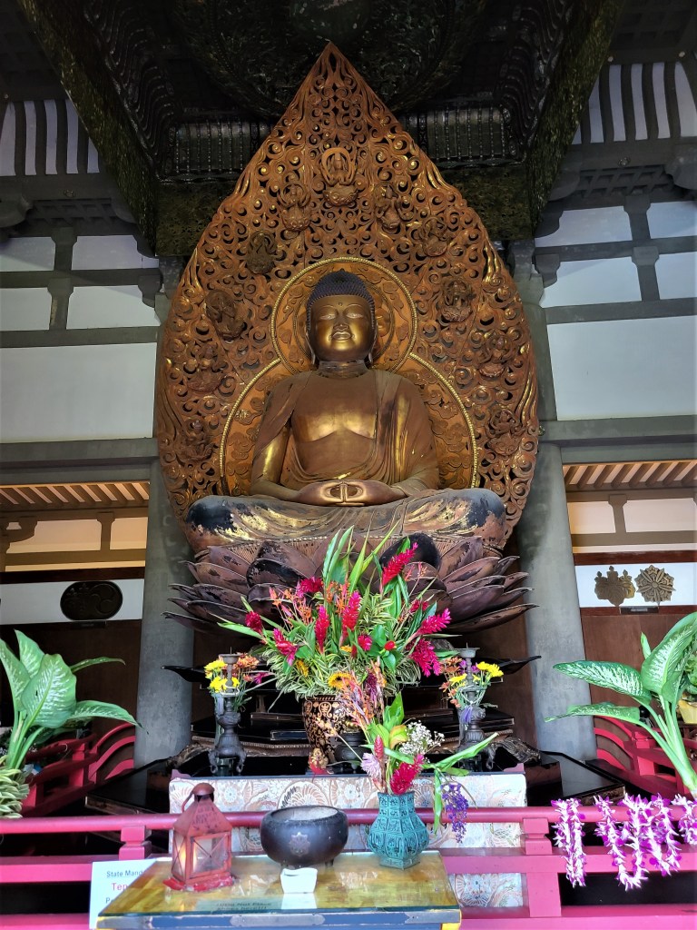
After visiting the little temple for a bit, sitting thinking about the various religions of the world, and my own personal belief system of one God for all mankind, I walked past the lady, taking my ball cap and shoes off to show respect. I stepped out the giant open door opposite to the Buda-On-Lotus figure, placed my shoes and ball cap on the sidewalk, and turned around and just stood a bit to enjoy the statue and the temple in general. The lady, who had been out on the entrance to the temple, approached me and asked if I would like a private tour of the mausoleum behind the Buda shrine. This sounded a bit strange, but having an interest in the religions of the world, I thought why not. My guide punched in a key code to the door lock, and we entered what would be a U-shaped entrance hall. She explained the eight-foot high cases of glass-fronted crypts each could hold up to six burial urns for families. As we walked into the larger room of similar tall wooden cases of burial chambers, it was fascinating how families had decorated their ‘cubby’ with elaborate scrolled woodwork, beautiful urns of every type, and photos of family members interred. The lady said a short Buddhist prayer of thanks for us being allowed to visit these loved ones, and as we approached a smaller, but still very nice image of Buda, she picked up a ceremonial ceramic bowl with a stone bottom, and used a little wand to rub the bowl until a soothing prayerful music came from the bowl. This was actually quite touching.
As we slowly made our way through this large room, with capacity for about 3,800 urns, we discussed religion, and she gave me much detail of the building. At some point, and I am not a very swift person, it occurred to me she was giving a very soft sales pitch! As we slowly made our way back to the exit point, it came clear to the message she was delivering: I could ‘reserve’ (purchase) one of the little glass fronted crypts for only $18,000. The crypt would hold up to six family member urns, and the family could tastefully decorate, or not. I could just place a ‘small’ down payment and pay the balance over eight years, with no interest. If I would make a decision today, she could even offer a 15% discount! All of this was extremely tastefully done, and I of course respectfully declined. What I can’t figure out is how this old guy, traveling alone, dressed reasonably well, fit the profile for her targets to deliver the sales pitch to. All in all I found the entire half hour quite interesting…..LOL.
From the photos I am sharing today, I think you will agree that if you do drive the H3, the five mile detour to the Valley of the Temples, and the $4 admission fee is worth the experience of enjoying the beauty of the temple.
After the temple visit, I drove a bit longer to a seaside state park. As I can’t resist doing, I took dozens of photos of the beautiful sea and mountains on the east side of Oahu…or any side as far as that goes.
Once again, I must apologize for the length of this musing. I hope that if you have a chance to visit this wonderful island, you can agree my words did a little justice of the beauty of the area.